Flood and coastal hazard overlay code
The Mackay Region Planning Scheme (MRPS) 2017 was prepared to manage growth and change across the Mackay Regional Council local government area. The purpose of the flood and coastal hazards overlay code within the MRPS is to ensure that development in areas subject to inundation in riverine and local flood events and/or located in coastal hazard areas, is planned, designed and constructed to minimise risk of hazards to people and property. The implementation of the code is supported by overlay maps which are generated from flood studies.
It is not feasible for council to complete flood studies over the entire region at one time. Instead, council has an ongoing program of works to map coastal and flood hazards across the region as detailed in the “Flood Study” section. Periodically, when updated hazard mapping produced by these studies becomes available, council will seek to make amendments to the MRPS to include the revised hazard mapping.
The Planning Act 2016 allows a local government to amend a planning scheme by following a process set out in the Ministers Guidelines and Rules 2017 according to the type of amendment being made. Updates to natural hazard mapping are considered a “minor amendment” as they ensure the planning scheme contains the most up-to-date information about the risks to life and/or property. State approval of updates to flood hazard area mapping, and subsequent amendment of the planning scheme based on localised flood studies is conditional on the study;
- being undertaken by an RPEQ,
- including climate change projections and;
- having been accepted by a local government
Prior to amending the scheme,council must give notice to every property owner affected by the planning change about the meaning of the change and how to obtain further advice. The sections below detail proposed amendments and provide a history of past amendments that have been made to overlay maps.
Minor amendment 5
Council is preparing Minor amendment 5 to the Mackay Region Planning Scheme 2017 (planning scheme).
This amendment, if adopted, will be incorporated into Version 4.0 of the Mackay Region Planning Scheme 2017 which will commence in late 2021.
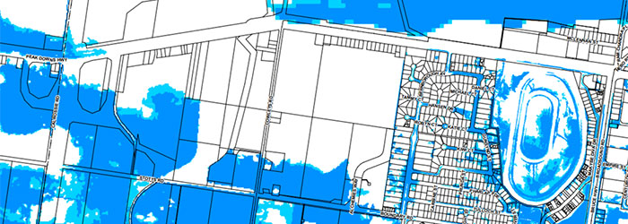
The purpose of Minor amendment 5 is to amend the Flood and coastal hazard overlay – flood hazard maps to reflect new flood hazard mapping from the following three drainage studies that were adopted by Council on 27 January 2021:
- The North Mackay Drainage Study (WRM 2019)
- The West Mackay Drainage Study (AECOM 2019)
- The Andergrove Beaconsfield Drainage Study (AECOM 2020)
Property owners affected by changes to flood hazard mapping are required to be notified. Letters have been sent to property owners affected by these changes. The following FAQ about the amended flood hazard overlay mapping may answer common questions related to the amended flood hazard
mapping.
Minor amendment 4
On October 28, 2020, council resolved to adopt Minor amendment 4 to the Mackay Region Planning Scheme 2017 (planning scheme).
These amendments are incorporated into Version 3.1 of the Mackay Region Planning Scheme 2017 which commences on November 9, 2020.
A full list of the amendments made is available here.
Mackay Region Planning Scheme 2017 version 3.1 is available here.
The purpose of Minor amendment 4 includes amending the Flood and coastal hazard overlay – flood hazard maps to reflect new flood mapping. The changes to the flood hazard overlay mapping reflect two flood studies that have been adopted by council:
- The Sandy Creek Catchment Flood Study - This flood study was adopted on February 12, 2020 and covers a stormwater catchment over parts of Eton, Drapers Siding, Homebush and Chelona before flowing into the Coral Sea at Dunnrock.
- The Rocky Dam Creek Catchment Flood Study - This flood study was adopted on February 12, 2020 which covers a stormwater catchment in the Koumala area, following the alignment of the Bruce Highway.
Adopted Flood and coastal hazard overlay maps available here.
Property owners affected by changes to flood hazard mapping are required to be notified. Letters have been sent to property owners affected by these changes. A FAQ has been prepared which may answer common questions related to the amended flood hazard mapping. See the FAQ about the amended flood hazard overlay mapping.
Minor amendment 3
On June 12, 2019, council resolved to adopt Minor amendment 3 to the Mackay Region Planning Scheme 2017 (planning scheme).
These amendments were incorporated into Version 2.2 of the Mackay Region Planning Scheme 2017 which commenced on June 17, 2019.
A full list of the amendments made is available here.
The purpose of Minor amendment 3 included amending the Flood and coastal hazard overlay – flood hazard maps to reflect new flood mapping. The changes to the flood hazard overlay mapping reflect two flood studies that have been adopted by council:
- The Bakers Creek South Mackay Stormwater Trunk Infrastructure Study - This flood study was adopted on March 13, 2019 and covers a stormwater catchment over parts of Ooralea, South Mackay and Paget.
- The Sarina Drainage Study - This study was adopted on November 14, 2018 which covers a stormwater catchment over land north of Plane Creek and west of the Bruce Highway in Sarina.
Property owners affected by changes to flood hazard mapping are required to be notified. Letters have been sent to property owners affected by these changes. A FAQ has been prepared which may answer common questions related to the amended flood hazard mapping. See the FAQ about the amended flood hazard overlay mapping.